
So, since I had to cut my trip short last year, I decided to pick up where I left off. And thus begins the story...
Aug. 25 2014
 I finished up loading the bike a little before 6:00 and was heading out by 6:20.
As I pulled onto highway 12 in Clarkston, I said to myself, "Ok, time to hunker down. It's going to be a long one."
I finished up loading the bike a little before 6:00 and was heading out by 6:20.
As I pulled onto highway 12 in Clarkston, I said to myself, "Ok, time to hunker down. It's going to be a long one."
 I got to see how the Low Fuel trip works on the new bike, at about 134 miles (depending on MPG at the time) it automatically turns on and switches to a "F" trip meter.
This shows you how many miles you have gone since the low fuel level has been reached.
This comes on much earlier than the need to switch to reserve. (which I never did need to do.)
I got to see how the Low Fuel trip works on the new bike, at about 134 miles (depending on MPG at the time) it automatically turns on and switches to a "F" trip meter.
This shows you how many miles you have gone since the low fuel level has been reached.
This comes on much earlier than the need to switch to reserve. (which I never did need to do.)
My first stop was 141.1 miles in, stopping in Pasco. This brought me to 7 miles on my low fuel trip. After some calculating, and checking my manual, I figure I can get 180'ish miles on a tank. I based my calculations on the worst of the MPG's that I got on the trip. I like to be conservative when riding. As they say, it's always easier to keep to top half of the tank full, then to walk 50 miles when you run out. (paraphrasing of course).
Anyway, back to the story. I jumped on I82 South until just before crossing the bridge to Umatilla, exiting onto highway 14. Highway 14 brought me the approximately 107 miles to Biggs Junction, where I stopped to fill up and have an early lunch at Dinty's. They make a pretty good sandwich for the kind of place it is. I liked it last year, so I decided I'd have another this year.
Before I got going again, I talked with a couple other bikers. One was from Spokane and asked about highway 14. Maybe a mile or two before I got to biggs it has fresh'ish chip seal. He was worried about it. It wasn't kicking up, and it was only for a mile or two, so I told him he should be fine.
Another asked if you can go south from here and get to Winnemucca, NV. After some checking on the GPS. The answer is Yes. Go south on 97 to Bend, then take 20 east and eventually you get on US95 south which takes you right into Winnemucca. (In case anyone wanted to know.)
Roberta had left me a text message, and since the reply was going to be more than two words, I called her back.
I forgot the clean the windshield when I filled up, so I did that, and then I was on my way again.
I made it down to Redmond, then over to Sisters. Then, I got on 242 to Eugene, so I could go over the pass, instead of going the long boring way around. We had to stop for a few minutes to wait for a semi to back down and turn around. He wasn't supposed to be on this road.

 Once we got going again, I stopped a few miles in at the Sea of Lava for some pictures.
There was a chipmunk there that had definitely been feed and was out begging for more.
I also got a picture of Mt Washington and Mt Jefferson.
Once we got going again, I stopped a few miles in at the Sea of Lava for some pictures.
There was a chipmunk there that had definitely been feed and was out begging for more.
I also got a picture of Mt Washington and Mt Jefferson.


 So, get this.
I'm out here in the middle of no where, and what do I encounter, but someone to speak with in Portuguese.
As I was climbing the stairs I past a lady and her son and she, commenting on my do-rag, said "é Brasil".
To which I responded "é isso mesmo".
After I had finished taking pictures, I encountered the lady again, in a less in the middle of the way place and we talked for a short minute.
They are, as she described it, Bolivian Brasilians.
We wished each other a good trip and she rejoined her group.
So, get this.
I'm out here in the middle of no where, and what do I encounter, but someone to speak with in Portuguese.
As I was climbing the stairs I past a lady and her son and she, commenting on my do-rag, said "é Brasil".
To which I responded "é isso mesmo".
After I had finished taking pictures, I encountered the lady again, in a less in the middle of the way place and we talked for a short minute.
They are, as she described it, Bolivian Brasilians.
We wished each other a good trip and she rejoined her group.
Once coming out of the forest, I soon came into Eugene, where I filled up and headed west on the 126, Florence-Eugene highway. I exited at the Whittaker Creek Recreation area. I stopped, repositioned the camera, got out the directions I had printed off, and despite the sign saying "Road closed 9 miles ahead", I started towards Kentucky Creek Falls. Yes, this is what I was doing when I bottomed out last year and ended up having to come home with the bike in a U-Haul. I never said I was the sharpest tool in the shed.
(audio removed due to copyright background audio.)
(audio removed due to copyright background audio.)
 As well as a picture of the bike next to the sign.
See, I made it without any incidents.
Sometimes, it just takes me a couple tries to get it right.
As well as a picture of the bike next to the sign.
See, I made it without any incidents.
Sometimes, it just takes me a couple tries to get it right.

 I hiked the 3/4 mile to the first falls and got some pictures.
However, it was getting dark, so I started heading back.
I was debating camping there at the trailhead, but finally decided against it.
I first tried to continue on the paved road that looked like it would have looped me back around, without having to go clear up on the hill again.
I hiked the 3/4 mile to the first falls and got some pictures.
However, it was getting dark, so I started heading back.
I was debating camping there at the trailhead, but finally decided against it.
I first tried to continue on the paved road that looked like it would have looped me back around, without having to go clear up on the hill again.
By the time I got back down, it was late and very dark. The place I had thought about camping was closed, which I had noticed on my way up. So, I was just looking for a place where I could pull off, and there was a couple of trees I could hang from. I finally found a place about 9:00.

I put a can of chile the sterno to heat while I put up my bed. I ate the chile with crackers, and went to bed. However, I wasn't able to sleep well. I'm not sure if it was because someone forgot to turn off the stream, or if it was some of the other noises. But I do know that the log trucks driving by at 2 and/or 3 am didn't help.

Aug. 26 2014
I got up a little after 6:00 and took a couple pictures.
I then started writing down the events from yesterday.
I also copied the pictures and videos from the cameras to the laptop, leaving the Drift connected to charge.
And now it's 7:45, so I better get moving...
Come to find out, camp was only 1.5 miles from the highway. With the speed of the log trucks that had been driving by all morning, I wasn't sure I'd make it to the highway, but I did. Continuing on towards the coast, I traveled through this tunnel. (video at left) There were several tunnels during the trip, but I think this one was the longest, so I decided to include it.
I stopped in Florence for fuel, where I chatted for a minute with a Canadian biker. He and his wife were doing a big loop and were going to go through Glacier on the way back.
Heading North now, I stopped at the Heceta Head Lighthouse. I first went out on the beach for a while, taking some pictures and enjoying the view and fresh sea air.


 I then "hiked" up to the lighthouse.
Taking some pictures along the way.
Once at the lighthouse, I was setting up the tripod, when a little girl sitting on a bench near me, looked up to see me in my do-rag.
She gasped and said "A pirate!"
There's only one response to that... So, I said "Argh".
I then "hiked" up to the lighthouse.
Taking some pictures along the way.
Once at the lighthouse, I was setting up the tripod, when a little girl sitting on a bench near me, looked up to see me in my do-rag.
She gasped and said "A pirate!"
There's only one response to that... So, I said "Argh".


There were a lot of wild black berries along the path. Some were ripe, so I had a few.
Once I made it back, I layered up again (it was still chilly), and continued on my way.
I stopped in Waldport at the Alsea Bay Bridge Interpretive Center and looked around. Taking some pictures of it and the bridge. The typed note in the typewriter was supposedly written by the engineer of the bridge.


Since I was here, and had plenty of time, I began the activities that I had planned for tomorrow.
First I stopped at the Glass Blowing shop. The guy was making some glass ornaments that had been ordered. In the first picture, note that hose in his mouth. The other end he attaches to the end of the pole, so he can blow the air into the glass and make it expand into the shape he wants. After he got the sphere the size and shape he wanted, he got more molten glass to shape the loop for the hook.


 There are many colors that can be used, by rolling the molten glass in the colored powder before shaping it.
There was many glass items for sale in the "gallery". Some of which were very intricate, while others were just you ordinary glass stuff. Still, kind of cool to watch in the making.

 Next, was the Hatfield Marine Science Center.
I found a couple things here.
Next, was the Hatfield Marine Science Center.
I found a couple things here.
First of all, I found some information on Barnacle Brads relatives. So, I had to take a picture of that.

 Then, I found Nemo and Dory.
 They also had a section with hands on marine life.
Most of which I saw and touched last year at Ocean World.
However, I did gently push on one of the spines of a sea urchin.
They are surprisingly sturdy, and when you push or touch them, they will change or move the position of the spines.
They also had a section with hands on marine life.
Most of which I saw and touched last year at Ocean World.
However, I did gently push on one of the spines of a sea urchin.
They are surprisingly sturdy, and when you push or touch them, they will change or move the position of the spines.
Next, I went to the Aquarium, which was basically next door.
Here are some of the things I saw:
Sea birds

|
Seals and Sea lions
|
|
Sea otters being fed
|
Eels
|
Juvenile japanese spider crab
You can't tell me this doesn't look similar to the spider looking stage of that one alien in that movie. |
Sharks
| ||
|
Little Jelly fish |
Big Jelly fish |
|
 I still had some time, so I went over to Nye Beach and walked around taking some pictures for a while.
The wind was blowing pretty good.
These two girls were running around playing in the wind with their towels.
And if you looked in the right direction and the right angle, it looked like you were in the desert, instead of on the ocean beach.
With the wind blowing like it was, it was making some cool designs in the wet sand as well.
And with the mist hiding the sea, the waves rolled in unseen until they lapped up on shore.
I still had some time, so I went over to Nye Beach and walked around taking some pictures for a while.
The wind was blowing pretty good.
These two girls were running around playing in the wind with their towels.
And if you looked in the right direction and the right angle, it looked like you were in the desert, instead of on the ocean beach.
With the wind blowing like it was, it was making some cool designs in the wet sand as well.
And with the mist hiding the sea, the waves rolled in unseen until they lapped up on shore.


 Having completed the planes for tomorrow, I went back to South Beach state park and setup camp.
I was surprised when the pizza delivery car showed up across the way at a campsite with a mother and daughter.
...Wow talk about timing, as I was just starting to write that sentence, the daughter walked over and asked if I wanted any pizza....
I had a late lunch, and I had some crackers and smoked salmon sticks for supper. So, I wasn't hungry for pizza.
I said, no thank you, and then added that they have been entertaining.
She chuckled and said something about her traveling circus.
Having completed the planes for tomorrow, I went back to South Beach state park and setup camp.
I was surprised when the pizza delivery car showed up across the way at a campsite with a mother and daughter.
...Wow talk about timing, as I was just starting to write that sentence, the daughter walked over and asked if I wanted any pizza....
I had a late lunch, and I had some crackers and smoked salmon sticks for supper. So, I wasn't hungry for pizza.
I said, no thank you, and then added that they have been entertaining.
She chuckled and said something about her traveling circus.
So, the entertainment... Let's see, there was the chopping wood. But not just chopping wood, mom was making daughter do it in slow motion so she could get a picture. Then, the daughter comes back from the restroom and proceeds to tell her mom how she opened a stall and some one was already in there. The way she told it, it was quite amusing. There were other things said that made me smirk, but I can't remember them. Just those off the cuff statements that make you smile.
After setting up camp, I took a nice warm shower. They have a pretty nice setup. Then I sat down with the aforementioned salmon and crackers and started writing the days events. And that brings an end to the day.
Aug. 27 2014
I think I slept much better last night.
It felt like a much deeper sleep. However, I think that made me much more of a tendency for the 30 second nightmare.
I heard a twig break waking me just enough to notice how tight the hammock was around me.
So, apparently, my mind devised a plan to have a couple guys, using the twine on the corners of the tarp that was hanging over me, tie me in so I couldn't get out.
And then proceed to steal my stuff.
But like I said, it was over in 30 seconds (or less), I rolled over and went back to sleep.
I got up around 6ish and, taking my time, got ready to go. By the time I was ready to leave, the mother daughter campers were up. As I was pulling out, the daughter looked over with a half dazed, "I'm not awake yet", look on her face. I waved goodbye and she smiled and waved back.
 My first stop of the day was at Devils Punch Bowl.
As you pull up to the parking lot, there is what looks to be maybe an old milk truck or maybe even an old ice cream truck that was converted into an ice cream stand.
I got some pictures of the surrounding shore line, waves and of course the actual Devils Punch Bowl.
It would have been much cooler at high tide.
My first stop of the day was at Devils Punch Bowl.
As you pull up to the parking lot, there is what looks to be maybe an old milk truck or maybe even an old ice cream truck that was converted into an ice cream stand.
I got some pictures of the surrounding shore line, waves and of course the actual Devils Punch Bowl.
It would have been much cooler at high tide.


 I then headed into Lincoln City.
I first went to the SpyGlass Ridge "Open Spaces" area for a hike.
At first it seems promising.
However, It didn't take as long as I had planned and for the most part it seemed like a hole bunch of rotting trees.
Not pretty at all.
I then headed into Lincoln City.
I first went to the SpyGlass Ridge "Open Spaces" area for a hike.
At first it seems promising.
However, It didn't take as long as I had planned and for the most part it seemed like a hole bunch of rotting trees.
Not pretty at all.
 I then went to the east devils lake recreation area.
I looked around and took a couple pictures.
But, without a boat or a picnic basket, there wasn't much to do here.
I then went to the east devils lake recreation area.
I looked around and took a couple pictures.
But, without a boat or a picnic basket, there wasn't much to do here.
Then, I headed for the beach.
I walked down the beach taking pictures and enjoying the view, the waves and the breeze. I came upon a crab that had been eaten from it's shell. There were many mussel shells that had also been emptied by the birds. There was a fire like looking design left in the sand by the run off of the outgoing tide. And there were several of these, I'm assuming, jelly fish of different shapes and sizes.


At a couple minutes past 11 a siren went off. No one on the beach seemed to be alarmed, so neither was I. I firgured that if it was a tsunami I could go out with my nearest and dearest complete strangers that were also walking the beach.

 Not long after, I did head back.
I planed to eat at Kyllo's Seafood & Grill and I wanted to beat the lunch rush.
I was leaning towards the Halibut, but when she mentioned the specials, she made the crab stuffed salmon with hazelnut salad sound so good.
It came served on top of garlic mashed potatoes.
I went with that and it was very good.
Not long after, I did head back.
I planed to eat at Kyllo's Seafood & Grill and I wanted to beat the lunch rush.
I was leaning towards the Halibut, but when she mentioned the specials, she made the crab stuffed salmon with hazelnut salad sound so good.
It came served on top of garlic mashed potatoes.
I went with that and it was very good.


Looking out the window you could see people flying kites on the beach. And running next to the building was "D" Worlds Shortest River.
As I finished lunch, I went to the restroom and the siren went off again. Again, no one was alarmed. It kind of reminded me of the 8:00 siren that goes off in Afton every morning. (Not sure, but that may be just during school.) Anyway, out in the parking lot, as I was getting ready to climb on the bike, a lady called from the street above, asking about the siren. I said that I also didn't know, as I was not from there. But now I know I wasn't the only one wondering.
I climbed aboard the bike and headed for Tillamook. On the way, I took a little detour to check out the Cape Lookout Campground. They didn't have any trees to hang from so that ruled them out.

 I pulled into the Tillamook Cheese Factory, and while looking for a spot to park another biker pointed out that there was room next to his bike.
He was on a big 6 cylinder Triumph.
I'm guessing a Rocket III Touring. I don't know why I didn't get a picture of it.
I pulled into the Tillamook Cheese Factory, and while looking for a spot to park another biker pointed out that there was room next to his bike.
He was on a big 6 cylinder Triumph.
I'm guessing a Rocket III Touring. I don't know why I didn't get a picture of it.


I had the cheese curd ("Squeeky" Cheese), smoked medium cheddar and garlic chili pepper cheddar in the cheese sampler line. I then got a waffle cone with a scoop of mountain huckleberry and a scoop of white chocolate raspberry. When I finished the cone, I went to the bike and tried to figure out what was next. I was debating on continuing north or go to the Jones Creek Camp like I had originally planned.


I finally decided that I would stick with the plan and rode out to the Tillamook Forest Center. This is where I searched for and found the first geocache (GC4PZ87) of the trip.
 Then, I went inside to look around.
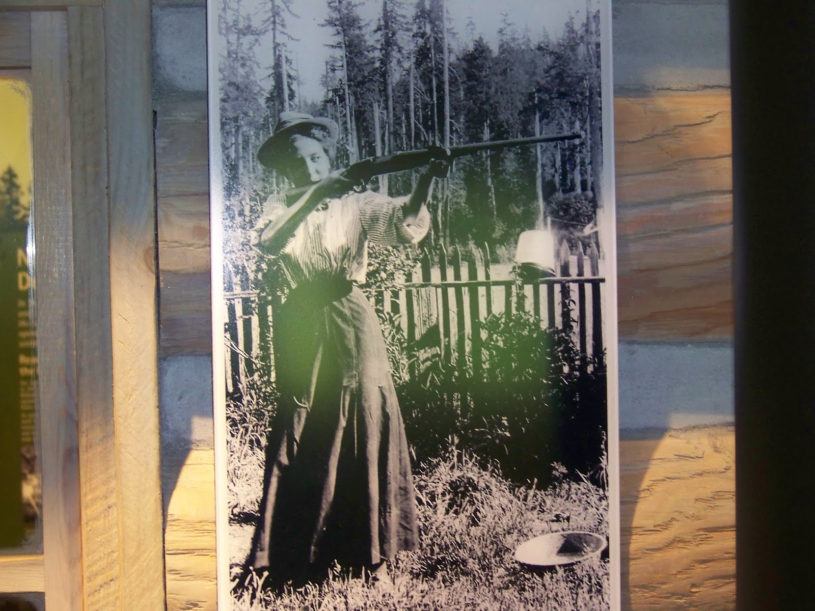
The picture of the picture reminded me of a picture my family has of my Grandma Hemmert getting an award for marksmanship.
I couldn't find the one I was thinking of, but I did find this one on the Ralph and Very Hemmert Family History Pictures Gallery CD that uncle Von made for us.
It is under Vera Gladys Herrington/herrington_vera_1935h_vera_ralph_shooting.
Or, on the Archive CD 2 under Ancestors\Herrington\Vera\herrington_vera_1935h_vera_ralph_shooting.tif.
Then, I went inside to look around.
The picture of the picture reminded me of a picture my family has of my Grandma Hemmert getting an award for marksmanship.
I couldn't find the one I was thinking of, but I did find this one on the Ralph and Very Hemmert Family History Pictures Gallery CD that uncle Von made for us.
It is under Vera Gladys Herrington/herrington_vera_1935h_vera_ralph_shooting.
Or, on the Archive CD 2 under Ancestors\Herrington\Vera\herrington_vera_1935h_vera_ralph_shooting.tif.


And for those that don't recognize these two... That one is a shortwave radio, and this one is a telephone. Yea, let's see you text on that.
 Once I was done there, I went the other .5 miles to the Jones Creek Campground.
I found a site and got camp setup.
Once I was done there, I went the other .5 miles to the Jones Creek Campground.
I found a site and got camp setup.
As I was trying to plan for tomorrow, I couldn't figure out why, if I'm a day and a half ahead of schedule on the activities, why haven't I skipped any of the planned camp spots? Then, I found it. I didn't have a camp spot planned for Wednesday. So, now the plan is tomorrow (Thursday) I will do Fridays activities and Friday I'll get home. And, I'll miss the storm that was supposed to hit me on Saturday. My luck... The storm will hit Friday.
Now that I got that out of the way, I sat down with the last two Salmon Sticks from the package I'd opened and some crackers and started writting. And that brings me to now.

Ok... So, there was still a little daylight left, so I tried for a second geocache. I was all over it's location but I failed to find it. GC141P5.
Hey Scott! ... Atta boy! ... ready? ... Fetch!
I walked out and around on the road to get to the area which was about a mile. Found the area and noticed the trail just down off the road. I searched for a while, but it was starting to get duskish and the shade of the trees made it more difficult, so I finally gave up.

 Going back, I followed the trail, which took me passed the bridge to the Tillamook Forest Center and right back to the camp ground.
That ended up only being .5 miles.
Going back, I followed the trail, which took me passed the bridge to the Tillamook Forest Center and right back to the camp ground.
That ended up only being .5 miles.
Ok. Now that's really the end of the day.
Aug. 28 2014
Up and at'em at 6:40.
Got loaded up and headed back to the highway.
I stopped at the Smith Homestead Day Use area to look for GC2DRG6.
I wasn't able to find this one either.
The GPS kept moving it on me.
First it was on this side of the trail, then it was on that side.
Once I gave up, I headed back into Tillamook.
Topped off the tank and then headed North.
I did stop for a little bit in Cannon Beach. Where I spent a little time at the beach. Yea, no irony there... Stopping at the beach in Cannon Beach.


 When I got there, I used the Drift to take a picture of me with the column.
That way I wouldn't have to get the tripod out.
Then, after removing a layer, I went looking for GC43FN5.
I think this is the one that said you get weird looks from the muggles.
When I got there, I used the Drift to take a picture of me with the column.
That way I wouldn't have to get the tripod out.
Then, after removing a layer, I went looking for GC43FN5.
I think this is the one that said you get weird looks from the muggles. I can understand why.
And I never found it.
But I did take a couple pictures while I was over there.
I can understand why.
And I never found it.
But I did take a couple pictures while I was over there.
Once I gave up, I went up the 164 steps of the column, taking the following couple pictures on the way and then some from the top.


 Once back down, I went in search of GC1VH3M.
And this time, I found it, and I have a picture to prove it.
So, I've found two out of the five I've looked for.
I think I'd have better odds if I would print out the geocache page so I could remember more about what/where to search.
That and I don't think my GPS is as accurate in short/close distances as the hand held models.
And, sure, I suppose that part of the problem could be me.
But really... come on.
Once back down, I went in search of GC1VH3M.
And this time, I found it, and I have a picture to prove it.
So, I've found two out of the five I've looked for.
I think I'd have better odds if I would print out the geocache page so I could remember more about what/where to search.
That and I don't think my GPS is as accurate in short/close distances as the hand held models.
And, sure, I suppose that part of the problem could be me.
But really... come on.
So, when I got back to my bike a gentleman asked if he could take a picture of my bike. He said he'd never seen one packed so high before. We chatted for a bit about biking and camping. He sold his bike because he just wasn't able to use it any more. He does take his kid's camping in the alps sometimes, but if there isn't a bed and a shower, his wife isn't going. So, now there is a Swedish guy out there with a picture of me and my bike.
|
| As I was riding down the road from the column, I came upon a deer. On the video you can see it at 40 seconds in on the right side of the road. (video at left) |


Now, the video on the right, it going through the tunnel and arriving at Ft Columbia State Park. This fort/park used to be a barracks and compound to defend the Columbia River. Below are some pictures of the things to see there.


 After finishing up at the fort, I headed back across the bridge and over to 39th Street to the pier.
So, it appears that Bumble Bee Foods has a presence on Pier 39.
And so do the sea lions.
After finishing up at the fort, I headed back across the bridge and over to 39th Street to the pier.
So, it appears that Bumble Bee Foods has a presence on Pier 39.
And so do the sea lions.


So, I finished off the plans for Astoria, so I topped off the tank and headed towards Mt. Rainier.
Just a couple miles before crossing the bridge into Longview WA, we came upon an accident.(video at left) It didn't look like there was much left to it by the time we passed. But if you look at the front corner of the gun metal gray car as I turn the camera, you can see it got banged up.
Coming up on the entrance to the Mt. Raineir park, there was the Country Inn that had an interesting design and a working water wheel.(video at right)
Once I got in the park, I went to the Cougar Rock campground to find a camp spot. This is the first time I have ever seen a campground that takes credit cards and uses a machine to print out your camp site ticket. I paid the fee, got my ticket and went looking for a good site. I found one pretty quick and setup camp.
I got on my bike and headed back about 2 miles to Longmire and the National Park Inn. My Dad used to watch a show called Longmire. Oh, but that is supposed to be a Wyoming town. Anyway, I had a chicken quesadilla for supper at the Inn. I wasn't hungry enough to eat the whole thing, but they served it with a summer corn and black bean salsa that is very very good. I asked for more to go with my left overs.
I did ask about the weather, and she did confirm that the radio had said that some rain was supposed to be moving in.

After I put my leftovers in the bike, I walked around and took a couple pictures and then headed back to camp, planning on returning in the morning. (The museum and admin buildings were closed for the night.)


I spent some time moving things around in case it did rain during the night. By the time I got done, it was too dark to write down the event of the day. So, I went to bed.
Aug. 29 2014
I woke up around 2am. It took a while, but I must have fallen back asleep because I woke up again at 6:00.
I got up and packed up.
I started writing yesterdays events, then decided to do the rest down at the Inn where I could plug in and recharge some batteries.
As I was putting the last things on the bike, a man from a site over stopped and we chatted a bit.
He is heading towards Lolo and probably going to camp below the Lochsa Lodge.
Being loaded up, I headed back to Longmire. I ordered a hot chocolate, plugged in and continued writing. The museum opens at 9:00, and it is 9:08 now. Hopefully I'll have enough battery life for the ride home.
So, I went and looked at the museum, the bus and the admin building, taking some pictures along the way. Here are some of them.


As I began my way over the hill on my way home, I stopped in several locations to take some pictures, as well as getting a couple videos.
| Christine Falls | Reflection Lakes | |

|

|

|
Peak from Stevens Canyon Rd
|
||
Peaks around Mt Rainier


Stevens Canyon Rd
Into the mist
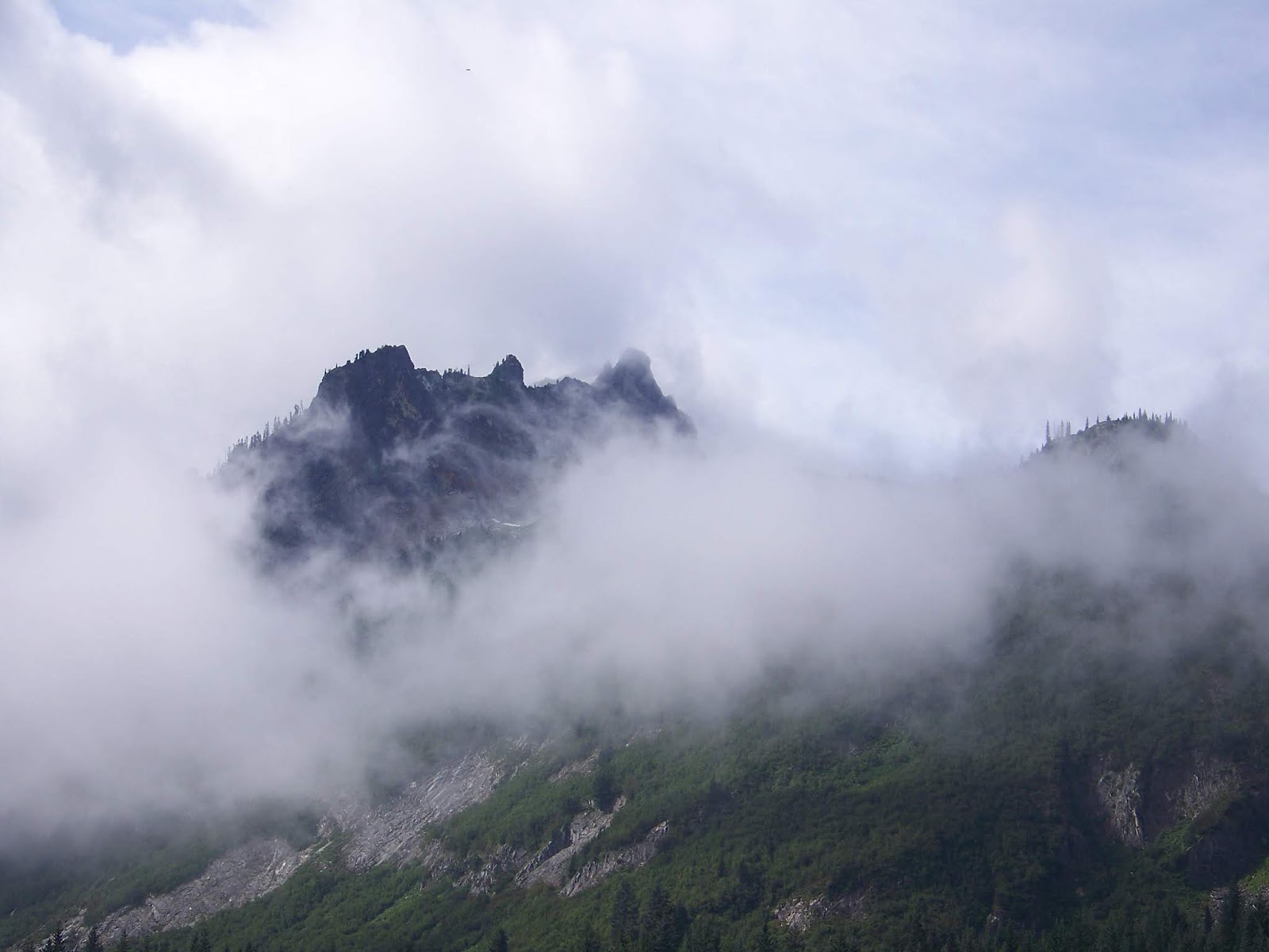


Stevens Canyon Rd
Into the mist
|
Stevens Canyon Rd Rocky wall and close edge |
Mt. Rainier | Mt. Rainier weather information |
|
|

Yup, it's in there somewhere. |

|
 Coming out of the park, I got on the highway and headed towards Yakima.
Hey Brad... Yellow!
I didn't stop in Yakima, even though I had planned to fill up there. But the road took me around and before I knew it I was on highway 24 headed east.
I stopped in Moxee to fill up, eat and rest a bit. A guy from the gas station chatted with me for a minute. He asked where I was from and when I mentioned Lewiston, he said, "Oh, yes, we're going through there on our way to Orofino for lumberjack days". I asked for directions to the city park and he gave them. After finishing at the station, I rode to the park.
 Before I ate, I rearangeed things on the bike, removed leathers and such, as it was getting pretty warm.
I then got out last nights leftovers and my camelpack (water) and went to a table to eat.
I took a couple pictures, used the restroom and was ready for another stretch of road.
Before I ate, I rearangeed things on the bike, removed leathers and such, as it was getting pretty warm.
I then got out last nights leftovers and my camelpack (water) and went to a table to eat.
I took a couple pictures, used the restroom and was ready for another stretch of road.


By the time I got to Othello, even though it had only been 75 miles, I was really missing the seat that's on the 96 Royal Star (which I sold). So, I stopped to top off the tank and stretch a little. Once done, I got on highway 26 and headed to Colfax.
About a mile or so out of town I passed a couple walking towards town, one carrying a small gas can. And I refer you to the statement I made towards the beginning of this story about keeping the top half of the tank full. About 9-10 miles later, I passed a car on the side of the road. They must have been walking for a while.
Arriving in Colfax, I took a left and went over to Steptoe Butte. Brad, you didn't tell me about all the potholes I would have to dodge. At the bottom of the butte, I pulled up just as a group of five bikes (four couples) were just getting ready to ride up. One of the ladies said the apples weren't good. After they pulled away, I did find some plum of some sort, but it was definitely not ripe yet. Then, I headed up as well. (video at right) The video was taken with the Kodak because the Drift batteries were dead.
 When I got to the top, the other group asked if I would take their picture, which I did.
Then, one of them took my picture for me as well.
They said it looks like I'm ready for a long trip.
I explained that I'm just ending the trip, but I had been doing the Oregon coast since Monday.
When I got to the top, the other group asked if I would take their picture, which I did.
Then, one of them took my picture for me as well.
They said it looks like I'm ready for a long trip.
I explained that I'm just ending the trip, but I had been doing the Oregon coast since Monday.
They headed back down the hill and I took some pictures. Then I headed back down as well.

I rode back into Colfax and filled up before heading home. Before I left the station, however, I got my pillow off the back and put it on my seat. It did help a bit. I then made the last 49 miles of the trip pulling into the yard at 6:26 pm.
As I was finishing up writing down the events for the day, I checked the weather. Sure enough, if I had pulled into Mt. Rainier park tonight, I would have gotten rained on. Maybe just a little during the night, but most definitely during the day tomorrow.

Warning!!!
This picture may not be suitable for all audiences
I gathered trip information for this writeup and found I put 1,458.3 miles on the bike. This put the odometer at exactly 6300 miles. Below are the tracks that I pulling off the GPS. Per the GPS, I went 1,475 miles over 4 day 12hr 37min and 8 seconds. Granted not all of that was when it was on the bike.

And that brings to a close this years edition of the August Ride. Thank you, and don't forget to tip your waitress.
AJ's Crazy Biker Adventures