

Ok, this year wasn't as long of a ride as past years (only 393 miles). That being said, here is the story.
At about 5:45 I was ready to go.
I took this picture:
And then put the camera in my bag, strapped the tripod on, put on my helmet and began the trip at 5:47. (Dad had already left to go fishing.)
I rode to swan valley at which point, I turned at the Square Ice Cream store and headed to Victor. I then turned left and went through Driggs, Tetonia, Felt, France and on into Ashton. I just have to say, the temperature, even though its not as cold as it could be, was still very cold on a bike with a short windshield. Even with my two, three, sometimes four and even five layers, I was feeling the cold. So anyway, I made my way over to US 20 and headed north.
Now, since I was on the KLR, and since I was a little earlier than planed, I did take a couple "detours" just for fun. I came up on Hatchery Ford Road, and said to myself, "Hey, that looks fun" and took it. Not even a minute on the road, my GPS recalculated and said, OK, I can take you this way and gave me directions that took me to Graveyard Flats road, which then lead me back to US 20. Then, not too much further down the road, I came upon Little Butte Road and decided to see where it lead. This time, the GPS thought for a moment and they said, You gotta turn around. However, I went up the road 3.3 miles, until it connected to another road. I then zoomed out on my GPS and found that all the roads did was take me further out into the woods, so I turned around and headed back to US 20.

Once back on US 20, I continued on towards Henry's Lake. I stopped for a little bit in Last Chance at the Last Chance General Store to use the restroom and warm up a bit. I bought a small hot chocolate and wandered the store until it was gone. As I was wandering, I came upon an Anniversary card that had a hill billy couple on the front and said, "You go together like biscuits and gravy". Then, on the inside, it had a recipe for biscuits and gravy. It reminded me of the conversation about white sausage gravy at the Elk Horn Restaurant.
Back on the road, I continued north through Island Park, turning onto Highway 87 and arrived at the turn off to the Sandau cabin at 10:02:55. Curt Sandau and some of the neighborhood men were there at the highway working on a new mailbox stand that would hold all the mailboxes. (Instead of each one having it's own stand.) I said hi to Curt and then I headed up to the cabin. Now, this road does not show on my GPS, I think it is considered a private road. So, as to not get lost and/or turn into the wrong house/cabin, I followed my 22 way-points that I had set last time I rode to the cabin. I only missed one turn, and I could tell right away, and was able to get back on the right trail.
When I pulled up to the cabin, Diane was out watering her plants. We chatted while she finished up, then as she wound up the hose and was attempting to remove the spay nozzle she was using, and she sprayed me! How rude! We went inside and sat down and chatted for a while, catching up on this and that. Diane got her camera and showed me the pictures of the many animals they have seen. They were up at the cabin almost a month earlier than usual this year, so they have been able to see some things that normally they aren't there for.
Curt came in and sat down and we continues to chat. Noon rolled around and Diane made us fixings for Tacos for lunch. As we were eating and chatting, Diane, looking out the window behind me, all of a sudden says; Oh, there's a moose. As we watched, come to find out it was three fairly young bull moose (meese?) that only had stubs for antlers. They walked over behind the boat and one headed up the hill. The other two hung out for a bit, and finally turned down towards some of the other cabins. Sorry, no pictures, my camera was still in my bag on the bike.

Curt's brother stopped by for a little bit and then left. We continues chatting until about 3 to 3:15. I then said, I better get going or it will be very late when I get home. After saying my Thank you's and goodbye's, I pulled away from the cabin at 3:28. I did stop down at the highway to switch to my thinner gloves, you know, since it has gotten warmed up. As I got things arranged, I decided I would take a picture of the mailbox stand that they had been working on. By the time I got my camera out, Curt showed up on the four wheeler to do some more work on it, in preparation for the next step. So, I took a picture of the new mailbox stand with him working on it. And they say retired people don't work.
During the time we were chatting at the Sandau cabin, we had discussed my return trip plans, and Diane mentioned, that if I don't want to go back the same way, I could take highway 47, the Mesa Falls Scenic byway. So, that is what I did. Here are some of the pictures: The falls are this way:
 Boy that snow depth, you can hardly believe it:
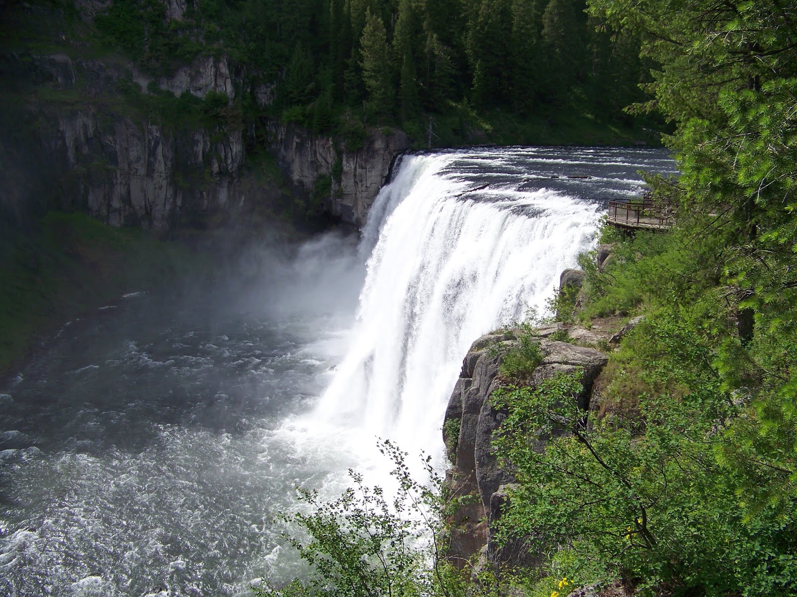 The Falls:
 Read all about it:
Due to the time, I didn't spend much time here, but there was a visitors center as well.


I stopped briefly in Ucon to top off the tank and call home. You see, I told Dad that I expected to be home around five. However, I didn't expect to spend five hours at the Sandaus. And since it was already 6:00... Well, you get the idea.

I headed toward Bone Idaho, and it was paved 99% of the way.
There sure were a lot of windmills between Iona and Bone.
The road then turned to hard pack/gravel depending on where you were at the time.
It was a pretty good road, no major potholes or anything, so I was able to make good time.
I made to Herman, which from what I could tell, was one house.
And then on to Gray.
As I was reaching Gray, the road switched back to a paved road.
I stopped here to take a few pictures of the wispy clouds over what according to the maps is the "Grays Lake National Wildlife Refuge".
Here is one of them.
Gray is about 4 miles from Wayan/highway 34, which is the main road that goes over Tincup.

As most of you would know, coming over Tincup, I came out in Freedom.
I beeped my horn a few times as I rode past Uncle Veldon and Aunt Veloys at 7:52.
I would have honked at Uncle Dan and Auntie Trudy as well, but they live on the other side of the turn to US 89.
I then road into Thayne and stopped to top off the tank.
I arrived home at 8:16.
And one last picture of the Bug splatter on the bike at the end of the trip.
And thus ends the 6th Longest Ride.
Thank you and don't forget to tip your waitress.